Sometimes we can forget how fantastic the Google Earth application, and what its arrival meant –back in 2005– for the field of virtual global exploration.
Even today, some are unaware of the existence of Google Earth, or who think that its operation is the same as Google Street View when the reality is that this last service was created from Google technology Earth.
For this reason, we have wanted to prepare this guide in which we review everything worth knowing about Google Earth, from its functions to the different applications that exist or the best ways to get even more out of this helpful tool.
- What is Google Earth?
- What are its main functions?
- What devices can it be used on?
- How can it be used online without downloading anything?
- How can it be used on mobiles or tablets?
- Other variants of Google Earth
- Google Earth Pro
- Google Earth VR
- Four cool things you can do with Google Earth

What is Google Earth?
Google Earth is an app that allows you to explore a virtual globe made from cartographic data and satellite images.
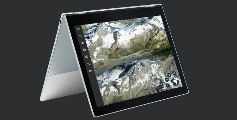
Earth stands out from other similar applications by offering high-quality satellite images, which generate a realistic and close-up view of the globe. To this must also be added the 3D modeling carried out by Google, which makes it possible to visualize the relief of hundreds of cities worldwide or the height of buildings and other structures.
It is free software with different versions available for most popular platforms, whether mobile or desktop. It is also possible to use Google Earth online without installing anything on our devices.
What are its main functions?

Google Earth is not just an exploration tool. Over the years, the platform has evolved through new features that make it a benchmark in its category.
Thus, in addition to viewing a precise representation of the globe through satellite images, it is also possible to travel to specific places by entering their name or address, as well as obtain the particular address of a business or draw on areas, customize the view or share areas with other people.
Other interesting functions are the option to give volume to valleys, mountains, or buildings, calculate the distance between two points on the map, check the height of mountains or see faults and volcanoes from much closer.
Since satellite images are used, it is also possible to visualize the state of the clouds in –almost– real-time in each of the locations on the planet, with fluid movements that show their evolution in the last 24 hours.
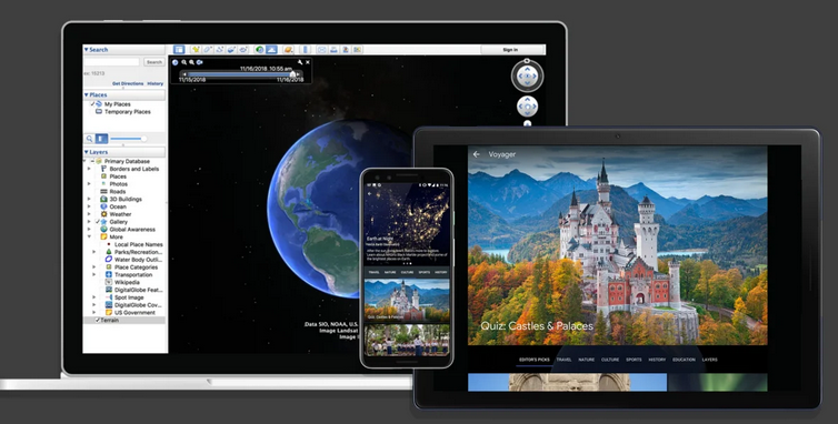
But Earth goes further. With its “Voyager” function, it is possible to discover stories about specific places told by experts or participate in mini-games that will put our skills in the field of geography to the test.
Another of its interesting functions is called “Projects.” It is possible to create colorful and attractive presentations using Google Earth technology to show different places in the world through its satellite images.
What devices can it be used on?
One of the advantages of Google Earth over other similar tools is its cross-platform format. It is possible to use Earth on various devices, from computers and tablets to smartphones.
How can it be used online without downloading anything?
The most common way to use Google Earth is through its web version available online through any device and without downloading.
To access it, you only need an Internet connection and a web browser compatible with the platform. Currently, only those that are based on Chrome technology are.
With this version, you can fly over any area of the planet in a matter of seconds, exploring cities and visiting places with 3D buildings. It is also possible to participate in guided tours through the Voyager function or create personalized maps and stories.
How can it be used on mobiles or tablets?
How could it be otherwise? Google Earth also has its mobile app. This version is available on both iOS and Android. It allows you to perform the same functions that you would find on the web version of the platform and some additional options that are only available in this version.
Unlike the online version of Google Earth, this variant does need to be installed, although it can also be downloaded for free and can be used on both Android phones and tablets and iOS and iPad.
Other variants of Google Earth

In addition to the previous versions, there are other additional Google Earth variants. It is possible to get even more out of the technology developed by Google: they are Google Earth Pro and Google Earth VR.
Google Earth Pro
Don’t be fooled by its name: Google Earth Pro is free to download. His last name refers to his advanced functions only available in this version of Google Earth for computers.
For example, with Google Earth Pro, importing or exporting GIS data, performing advanced distance measurements of areas, or working with cadastre from some countries is possible.
In this sense, thanks to the cadastre functions of Google Earth, you can see the square meters of a specific area, the last sale price of a property, the average income or age of a site, and many other relevant data for some professionals or amateurs.
Google Earth Pro is free to download and is compatible with Windows, Linux, or macOS computers.
Google Earth VR
And if none of the above is enough, you can always go even further with Google Earth VR, the version of Google Earth in virtual reality that allows you to explore the world in an even closer way, as if we were the ones flying over it.
Google Earth VR is available on the HTC Vive and Oculus Rift platforms and is entirely free to download.
Four cool things you can do with Google Earth
In addition to visiting any place on planet Earth with Google Earth, it is also possible to do many other things that you may never have thought of.
Because beyond its functions, Google Earth hides other secrets and hidden processes worth taking into account.
visit other planets
Yes, you can visit other planets with Google Earth. In addition to showing faithful representations of the stars and constellations, Google Earth also allows you to see planets like Mars or satellites like the Moon.
Yes, it is necessary to access Google Maps using the link below.
A free flight simulator
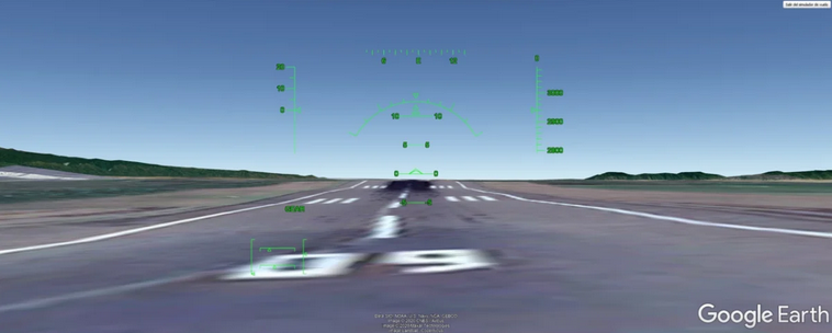
Probably one of the best features of Google Earth that has ever existed: the flight simulator built into the platform.
With it, you can get behind the controls of an F-16 or SR22 aircraft and travel the world or visit some of the most popular airports on the planet. Best of all, this feature is compatible with dedicated joysticks so that you can get an experience at the level of the famous Microsoft Flight Simulator –with a much less advanced graphic section, yes–.

travel in time
For some years now, Google Earth has given the possibility of “time travel.” This function, yes, is only available in Google Earth Pro, and thanks to it, it is possible to check what some areas of the world were like decades ago through the historical images stored by Google Maps.
Refresh your home screen
What if I told you that Google Earth could also be used to personalize your mobile or computer? On some other occasion, Google has delighted us with awesome wallpapers of satellite images extracted from Google Earth, perfect to set as wallpaper on our devices.
But if you want, you can also capture your images while using Google Earth and save them to later use as wallpaper on your mobile, tablet, or PC.
By now, you should be quite the Google Earth expert. There is no doubt that the tool hides excellent potential that anyone can start taking advantage of from any device and anywhere.

Sharlene Meriel is an avid gamer with a knack for technology. He has been writing about the latest technologies for the past 5 years. His contribution in technology journalism has been noteworthy. He is also a day trader with interest in the Forex market.


![How to Watch UFC 303 Live Stream Free [Updated 2024] UFC 259 Live Stream Free](https://techsmartest.com/wp-content/uploads/2022/03/UFC-259-Live-Stream-Free-100x70.jpg)

