How Google Maps and Waze differ: the main features in comparison and when it is good to use one or the other navigator.
Most users today use Google Maps as a navigator, even for car journeys. The “finer palates” have historically used Waze to navigate the traffic and reach the set destination.
What, then, are the differences between Google Maps and Waze, and why choose one or the other?
Let’s start by saying that we have always installed both Google Maps and Waze on our smartphones: one fills the gaps of the other and, above all, adapts to very specific usage scenarios. Although for a few months now, Google Maps has begun to inherit some features of Waze.
Being both from Google (the Mountain View company acquired Waze in June 2013), it is curious that it has not yet decided to integrate the two applications. But, in the end, it is perhaps good for users.
Comparison between Google Maps and Waze: the main differences
We summarize below the main differences between the two applications:
– Google Maps is not just a navigator: it is an app for consulting maps and a tool for accessing Street View from mobile devices. Conversely, Waze is a pure sat nav.
– Both Waze and Google Maps do not need an always-on data connection to work.
In the case of Waze, there are no areas to select. As soon as you define a destination with the Internet connection available and working, the application creates a cache with all the data on the path to follow.
As soon as Waze has established the path, before starting navigation, all the data collected will be downloaded, stored, and used even in the absence of an Internet connection (the important thing is not to close Waze).
– Waze is a “social” navigator: it allows you to receive real-time information on the best routes to follow to save time, it allows you to get alerts on the presence of accidents, traffic, dangerous situations, speed cameras, police forces, and so on Street. To contribute, during the trip, just tap the icon at the bottom right and choose the type of report you want to send. Google Maps shows general traffic information and reports any congestion but cannot receive any feedback from other drivers.
Only with the most recent versions of Google Maps has support been introduced for indicating the presence of speed cameras along the route.
The reports are made in real-time and draw on the database, also exploited by Waze: the nice thing is that by clicking on the Maps Options, users can report mobile speed cameras.
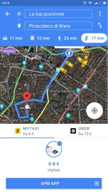
– Waze is only suitable for getting turn-by-turn directions in the car, while Google Maps can be used to request directions for travel by car, public transport, on foot, by bike, by taxi, and by Uber.
And the functionality also works well and is very useful for getting around on foot in unknown cities.
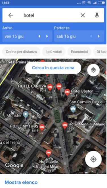
– Google Maps provides useful information on commercial services: opening and closing times, menus in the case of restaurants, hotel prices, telephone numbers, direct booking for hotels and restaurants, special offers, and so on. In the short term, by exploiting users’ information – often in the form of photos – Google Maps will also improve the database relating to restaurant cards. Waze does not foresee these possibilities.
– Waze has a clean and stripped down interface, even when it comes to viewing maps. On the other hand, Google Maps is richer in this sense and “less readable” in the car.
– Google Maps supports voice search. Thanks to the Google assistant, it allows you to find points of interest nearby and start the navigator without ever physically interacting with the phone.
L’Audio and Voice instructions in the settings and then selecting Voice commands. However, speech recognition is only enabled manually, for example, by tapping the screen with three fingers.
By simply pronouncing Report or Navigation, you can send a report or activate navigation to home or the workplace.
In some countries, Google has introduced the ability to use the “magic phrase” OK, Waze with the ability to send complex requests to Waze.
In Italy, as in other regions, it seems that we want to focus a lot on integration with the Android Auto platform: Android Auto: what it is and how it works.
Waiting for the news to debut during the summer of 2019, it is already possible to configure Android Auto by setting Waze (or Google Maps) as the default navigator.
Even in the case of Waze – with the Android Auto screen active and displayed – it is possible to use Google Assistant to ask to ” navigate to ” a certain destination (the digital assistant will reply ” OK, let’s use Waze ” or ” OK,
However, Google Maps is not very customizable, while Waze allows you to adjust every aspect of its operation: it is even possible to use the guiding voices of famous people.
By choosing the Audio and Voice Instructions item in the Waze settings, tapping Driving Instructions Voice, and then Record a New Voice, you can even record the various voice directions with your voice or that of a loved one.
– Regarding data consumption, Waze is thrifty: it only consumes 500 KB-1 MB per hour while driving. Even Google Maps is not ravenous, leaving the normal map selected and not the satellite mode. However, the largest amount of data is consumed in the travel setup phase (as seen above). Downloading offline maps allows you to reduce or almost eliminate data consumption while on the move.
When to use Waze and when to Google Maps
To travel by any means other than your car, it is good to start Google Maps and let yourself be guided by its directions.
Especially for walking, make sure your phone is calibrated correctly; otherwise, you may receive conflicting directions or see your position not perfectly reproduced on the map: GPS does not work on Android: how to calibrate the compass.
By tapping the Go icon in Google Maps then the last icon on the right (available only in larger cities), it is even possible to book a ride with a taxi or Uber by making the payment without ever reaching for your wallet.
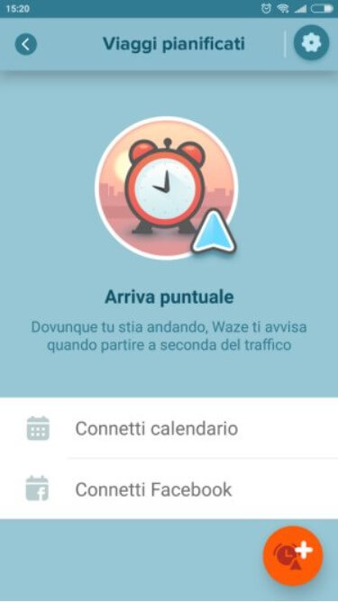
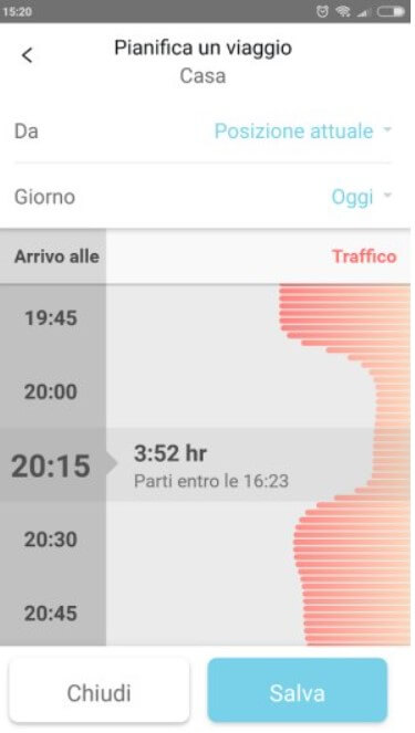
To avoid car traffic and be reasonably sure you arrive on time at your destination, Waze is unrivaled. By accessing the app’s main menu (which can be called up by tapping the icon at the bottom left) and then choosing Planned, you can set up an itinerary. After choosing the destination, Waze shows the recommended departure time and estimated arrival time.
If traffic conditions change, Waze can alert the user by informing them of the best times to travel and arrive at their destination without too much difficulty.
Waze can also be integrated with your calendar so that the app automatically knows times and destinations.
In the case of Waze, it is also possible to touch the Send ETA button, acronym for an estimated time of arrival (or ” estimated time of arrival “) to send to one or more contacts (selectable from the phone book), the time in which you will likely arrive at your destination. By choosing Itineraries, as in Google Maps, it is possible to evaluate and take any alternative routes.

Therefore, Waze is the app to be preferred when traveling by car because you will automatically receive information on the position of speed cameras (fixed and mobile locations), accidents, dangers, and slowdowns. In heavy traffic, it is possible to take an alternative route and arrive at your destination without too much delay.
On the other hand, Google Maps remains an excellent choice for travel by public transport, on foot or by taxi / Uber.
It is also ideal for getting directions to nearby points of interest, petrol stations, hotels, restaurants, bars, and ATMs.
To learn more about Google Maps’ use, we suggest reading the article Google Maps navigator but not only: all the most useful features.
Regardless of the application used, opening Google Maps, going to the main menu, and then choosing History will access the so-called ” movement history ” of Google, accessible from the desktop and clicking here.
This function shows in detail all the routes that have been followed (just touch the agenda icon at the top right, then choose a day on the calendar).
For more information, see our article Clear Google History – it’s now much easier and fastere.
Use of widgets with both Google Maps and Waze
Both Google Maps and Waze offer the ability to create widgets to place on the mobile device’s home screen. These are mini-apps that allow you to quickly perform certain operations.
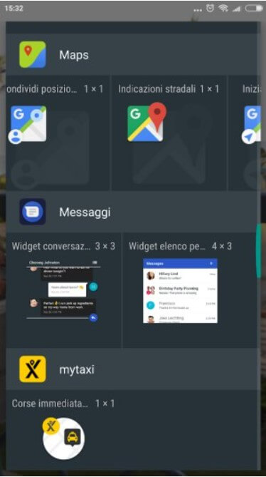
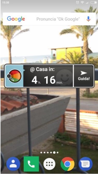
Google Maps offers widgets to instantly share your location, get directions to a recurring destination, and get a friend’s location and traffic information.
In the case of Waze, after setting Home and Work, you can use the special widget that allows you to quickly activate navigation (tap Help ).
To test how Google Maps and Waze behave in a specific area of the world, just install this Android app that allows you to “fake” your geographical position. After activating the Android geolocation services, the app allows you to change the place where you are, even in the absence of the GPS signal (for example, in closed spaces).

A tech-savvy writer with a knack for finding the latest technology in the market, this is what describes John Carter. With more than 8 years of experience as a journalist, John graduated as an engineer and ventured soon into the world of online journalism. His interest includes gadget reviews, decoding OS errors, hunting information on the latest technology, and so on.


")


")

